Create new RichFaces Documentation Jira issue

This will launch the RichFaces Jira page - to complete your feedback please login if needed, and submit the Jira.
JBoss.orgCommunity Documentation
The component presents the Microsoft Virtual Earth map in the JSF applications.
Presents the Microsoft Virtual Earth map functionality
Highly customizable via attributes
No developers JavaScript writing is needed to use it on a pages
Table 6.579. rich : virtualEarth attributes
| Attribute Name |
Description

|
|---|---|
| binding | JSF: The attribute takes a value-binding expression for a component property of a backing bean |
| dashboardSize | Initial map type. The possible values are "Normal", "Small", "Tiny". Default value is "Normal". |
| id | JSF: Every component may have a unique id that is automatically created if omitted |
| lat | Initial latitude coordinate in degrees, as a number between -90 and +90. Default value is "37.9721046". |
| lng | Initial longitude coordinate in degrees, as a number between -180 and +180. Default value is "-122.04248428346". |
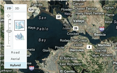
| mapStyle | Navigation control size. Possible values are "Road", "Aerial", "Hybrid", "Birdseye". Default value is "Road" |
| onclick | DHTML: The client-side script method to be called when the element is clicked |
| ondblclick | DHTML: The client-side script method to be called when the element is double-clicked |
| onkeydown | DHTML: The client-side script method to be called when a key is pressed down over the element |
| onkeypress | DHTML: The client-side script method to be called when a key is pressed over the element and released |
| onkeyup | DHTML: The client-side script method to be called when a key is released |
| onLoadMap | The client-side script method to be called when the Virtual Earth object is initiated |
| onmousedown | DHTML: The client-side script method to be called when a mouse button is pressed down over the element |
| onmousemove | DHTML: The client-side script method to be called when a pointer is moved within the element |
| onmouseout | DHTML: The client-side script method to be called when a pointer is moved away from the element |
| onmouseover | DHTML: The client-side script method to be called when a pointer is moved onto the element |
| onmouseup | DHTML: The client-side script method to be called when a mouse button is released |
| rendered | JSF: If "false", this component is not rendered |
| style | HTML: CSS style rules to be applied to the component |
| styleClass | JSF: Assigns one or more CSS class names to the component. Corresponds to the HTML "class" attribute. |
| var | The JavaScript variable that is used to access the Virtual Earth API. If you have more than one Virtual Earth components on the same page, use individual key for each of them. Default value name is "map". |
| version | Virtual earth version, Default value is "6.1". |
| zoom | Initial zoom level as a number between 1 and 18. Default value is "17". |
Table 6.580. Component identification parameters
| Name | Value |
|---|---|
| component-type | org.richfaces.VirtualEarth |
| component-class | org.richfaces.component.html.HtmlVirtualEarth |
| component-family | org.richfaces.VirtualEarth |
| renderer-type | org.richfaces.VirtualEarthRenderer |
| tag-class | org.richfaces.taglib.VirtualEarthTag |
To create the simplest variant on a page use the following syntax:
Example:
...

<rich:virtualEarth lat="..." lng="..."/>

...
Example:
import org.richfaces.component.html.HtmlVirtualEarth;

...

HtmlVirtualEarth myMap = new HtmlVirtualEarth();

...
Here are the main settings of initial rendering performed with a component map that are accessible with the following attributes:
"zoom" defines an approximation size (boundary values 1-18)
"lat" specifies an initial latitude coordinate in degrees, as a number between -90 and +90
"lng" specifies an initial longitude coordinate in degrees, as a number between -180 and +180
"dashboardSize" specifies a type of a rendered map (Normal, Small, Tiny)
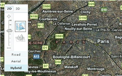
For example, the city of Paris is shown after rendering with
the following initial settings:
lat = "48.833"
,
lng = "2.40"
and
zoom = "11"
.
Code for this example is placed below:
Example:
...

<rich:virtualEarth  style="width:800px;" id="vm" lat="48.833" lng="2.40"

                                     dashboardSize="Normal"  zoom="11" mapStyle="Hybrid" var="map" />

...
To set all these parameters and perform some activity (Zoom In/Out etc.) is possible with your JavaScript, i.e. declare a name of an object on a map in the "var" attribute and then call the object directly with API Microsoft Virtual Earth map .
For example, to approximate a map for
var = "map"
declared inside the component, call
map.ZoomIn()
on an event.
Moreover, to add e.g. some JavaScript effects, events defined on it are used.
"onmouseover"
"onclick"
"onmouseout"
etc.
Virtual Earth does not support XHTML format of the page. Thus, if you use Facelets and JSF 1.2, do not forget to put the following tags somewhere on the page:
...

<f:view contentType="text/html">...</f:view>

...
<rich:virtualEarth> component isn't tied to skin parameters, as there is no additional elements on it, except the ones provided with Virtual Earth map .
Table 6.581. Classes names that define a component appearance
| Class name | Description |
|---|---|
| rich-virtualEarth | Defines styles for a wrapper <div> element of a component |
In order to redefine styles for all <rich:virtualEarth> components on a page using CSS, it's enough to create class with the same name and define necessary properties in it.
To change styles of particular <rich:virtualEarth> components, define your own style class in the corresponding <rich:virtualEarth> attribute.
Here you can found additional information about Microsoft Virtual Earth map.
Some additional information about usage of component can be found on its LiveDemo page.